August 19, 2007 Severe Weather Event
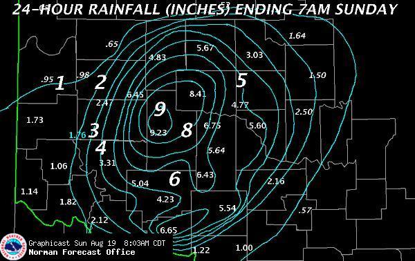
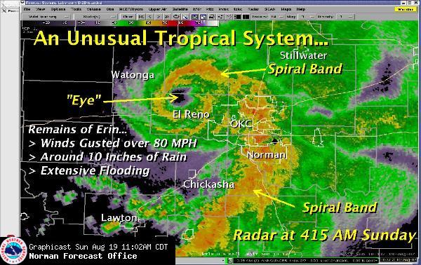
On Saturday, August 18, the remnants of Tropical Storm Erin moved towards Oklahoma from west Texas. Widespread rainfall occurred across western parts of Oklahoma with isolated activity in central sections. During the overnight hours the rainfall intensified across western Oklahoma. By early morning Sunday Erin, in a rare occurrence, had regenerated near Blaine County in western Oklahoma. An "eye" feature was noted on RADAR, as showers and thunderstorms intensified near the center (eye). Widespread excessive rainfall occurred in west-central Oklahoma and progressed east with Erin as it moved into central Oklahoma. By late morning Erin had lost the "eye" feature, but was still producing widespread showers and thunderstorms in eastern Oklahoma.
DRC's Open in Canadian, Cleveland, and Okmulgee Counties - September 26
FEMA Approves More Counties for Assistance - September 17
Disaster Recovery Center in Kingfisher County Opens Tuesday - September 10
State's Damage Assessment Hotline to Close Friday - September 4
Situation Update 5 - August 24
OEM Operating Damage Assessment Hotline - August 23
Situation Update 4 - August 21
Situation Update 3 - August 19
Pictures - August 19
Situation Update 2 - August 19
Situation Update 1 - August 19
Images below are from the Norman NWS Office.