Hydrologic Investigations
Oklahoma statutes direct the OWRB to conduct hydrologic investigations to determine the amount of fresh groundwater available for appropriation. Staff hydrogeologists, modelers, engineering consultants, and federal agencies assist in characterizing hydrologic properties of aquifers as well as recharge, effects of pumping, and water demand. Investigations include the determination of the upper, lower, and lateral boundaries of the groundwater basin as well as aquifer properties, such as saturated thickness, hydraulic conductivity, transmissivity, specific yield, and storage coefficient, to understand the storage and yield capacity of the basin.
Major Aquifers: Investigation Status & Related Reports
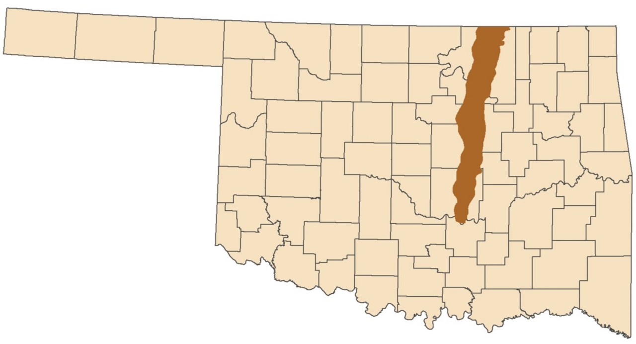
The Ada-Vamoosa aquifer underlies 1,975 square miles of northern and central Oklahoma, including portions of Creek, Lincoln, Okfuskee, Osage, Pawnee, Payne, Pontotoc, Pottawatomie, and Seminole counties. Wells commonly yield 1.2 to 290 gallons per minute. The aquifer is primarily used for public supply and domestic purposes.
- Study in progress. Contact the OWRB for more information.
- Aquifer tests and characterization of transmissivity, Ada-Vamoosa aquifer on the Osage Reservation, Osage County, Oklahoma 2006 (2008)
- Water quality of the Quaternary and Ada-Vamoosa aquifers on the Osage Reservation, Osage County, Oklahoma, 1997 (2000)
- Geohydrology of the Vamoosa-Ada aquifer east-central Oklahoma with a section on chemical quality of water (1986)
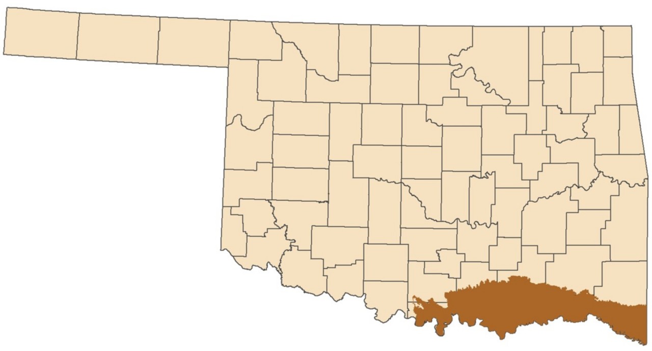
The Antlers aquifer underlies 4,400 square miles of southeast Oklahoma, including portions of McCurtain, Choctaw, Pushmataha, Bryan, Atoka, Love, Marshall, Carter, and Johnston counties. Wells commonly yield 100 to 500 gallons per minute. The saturated thickness is up to 1,000 feet. The aquifer is primarily used for domestic purposes.
- Hydrogeologic Investigation, Framework, and Conceptual Flow Model of the Antlers Aquifer, Southeastern Oklahoma (1980-2022)
- Simulation of ground-water flow in the Antlers aquifer in southeastern Oklahoma and northeastern Texas (1992)
- Geohydrology of the Antlers aquifer (Cretaceous), southeastern Oklahoma (1981)
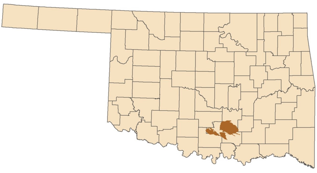
The Arbuckle-Simpson aquifer underlies 612 square miles of south-central Oklahoma, including portions of Carter, Coal, Johnston, Murray, and Pontotoc counties. Wells commonly yield 100 to 500 gallons per minute. The mean saturated thickness is 3,400 feet. The aquifer is primarily used for public supply and irrigation.
- Hydrogeology and Simulation of Groundwater Flow in the Arbuckle-Simpson Aquifer, South-Central Oklahoma (2011)
- Board Order Determining the Maximum Annual Yield for the Arbuckle-Simpson Groundwater Basin (2013)
- Arbuckle-Simpson Groundwater Basin Buffer Zones Map
- Arbuckle-Simpson Hydrology Study Fact Sheet
- Arbuckle-Simpson Hydrology Study Timeline of Events
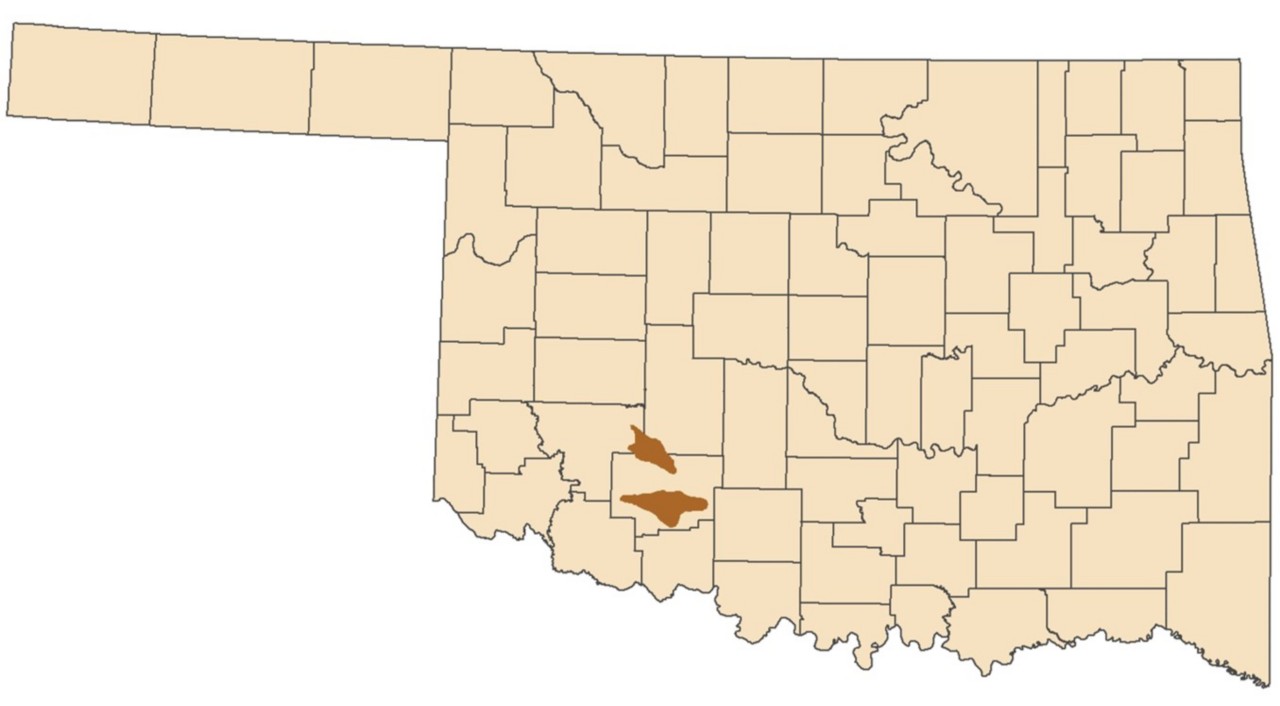
The Arbuckle-Timbered Hills aquifer underlies 376 square miles of southwest Oklahoma, including portions of Caddo, Comanche, and Kiowa counties. Wells commonly yield greater than 50 gallons per minute. The aquifer is primarily used for irrigation, agriculture, public supply, and domestic purposes.
The Arkansas River aquifer underlies 858 square miles of northeast Oklahoma, including portions of Haskell, Kay, Le Flore, Muskogee, Noble, Osage, Pawnee, Sequoyah, Tulsa, and Wagoner counties. Wells commonly yield greater than 100 gallons per minute. The aquifer is primarily used for irrigation, public supply, and domestic purposes.
- Study pending. Contact the OWRB for more information.
- Aquifers of Arkansas-protection, management, and hydrologic and geochemical characteristics of groundwater resources in Arkansas (2014)

The Blaine aquifer underlies 930 square miles of southwest Oklahoma, including portions of Beckham, Harmon, Greer, and Jackson counties. Wells commonly yield 300 to 2,000 gallons per minute. The aquifer is primarily used for irrigation.
- Study in progress. Contact the OWRB for more information.
- Blaine aquifer in the Hollis Basin of southwest Oklahoma; structure-contour map and stratigraphic-hydrologic data (2019)
- Brackish groundwater in the Blaine aquifer system, north-central Texas (2016)
- Demonstration and Evaluation of Artificial Recharge to the Blaine Aquifer in Southwestern Oklahoma (1997)
- Hydrogeologic data for the Blaine aquifer and associated units in southwestern Oklahoma and Northwestern Texas (1997)
- Hydrogeology and karst of the Blaine Gypsum-Dolomite aquifer, southwestern Oklahoma (1990)
- Hydrogeology and recharge of a gypsum-dolomite karst aquifer in southwestern Oklahoma (1985)
- Groundwater resources Harmon and parts of Greer and Jackson counties, Oklahoma (1965)

The Boone-Roubidoux aquifer underlies about 4,600 square miles of northeastern Oklahoma, including portions of Adair, Cherokee, Craig, Delaware, Mayes, Muskogee, Nowata, Ottawa, Rogers, Sequoyah, and Wagoner counties. Wells completed in the Roubidoux commonly have yields ranging from 100 to 1,000 gallons per minute. Wells completed in the Boone typically average less than 10 gallons per minute, but higher yields are possible where fractures or caverns occur. The aquifer is primarily used for public supply, agriculture, and domestic purposes.

The Canadian River aquifer underlies 242 square miles (Reach 1) of west-central Oklahoma and 364 square miles (Reach 2) of central and east-central Oklahoma. Reach 1 includes portions of Blaine, Caddo, Custer, Dewey, Ellis, and Roger Mills counties. Reach 2 includes portions of Caddo, Canadian, Cleveland, McClain, McIntosh, Pittsburg, Pontotoc, Pottawatomie, and Seminole counties. Wells commonly yield more than 100 gallons per minute. The saturated thickness up to 90 feet. The aquifer is primarily used for irrigation and public supply.

The Cimarron aquifer underlies 1,342 square miles of northwest Oklahoma, including portions of Alfalfa, Garfield, Kingfisher, Lincoln, Major, and Woods counties. Wells commonly yield 50 to 200 gallons per minute. The mean saturated thickness is 30 feet. The aquifer is primarily used for irrigation and public supply.
- Hydrologic Investigation Report of the Cimarron River Alluvium and Terrace Aquifer in Northwestern Oklahoma (2025)
- Hydrologic data for the alluvium and terrace deposits of the Cimarron River from Freedom to Guthrie, Oklahoma (1994)
- Groundwater Resources of the Terrace Deposits Along the Northeast Side of the Cimarron River in Alfalfa, Garfield, Kingfisher, and Major Counties, OK (1953)

The Elk City Sandstone aquifer underlies 519 square miles of west-central Oklahoma, including portions of Beckham, Custer, Roger Mills, and Washita counties. Wells commonly yield more than 50 gallons per minute. The saturated thickness is up to 199 feet, with a mean of 56 feet. The aquifer is primarily used for public supply and irrigation.

The Enid Isolated Terrace aquifer underlies 174 square miles of north-central Oklahoma, including portions of Alfalfa and Garfield counties. Wells commonly yield 20 to 250 gallons per minute. The saturated thickness is up to 65 feet, with a mean of 14.8 feet. The aquifer is primarily used for public supply and irrigation.

The Garber-Wellington aquifer underlies 3,000 square miles of central Oklahoma, including portions of Payne, Logan, Lincoln, Oklahoma, Cleveland, and Pottawatomie counties. Wells commonly yield 1 to 290 gallons per minute. The saturated thickness is up to 920 feet. The aquifer is primarily used for public water supply.

The Gerty Sand aquifer underlies 97 square miles of south-central Oklahoma, including portions of Garvin, McClain, and Pontotoc counties. Wells commonly yield 100 gallons per minute. The saturated thickness is up to 64 feet, with a mean of 14 feet. The aquifer is primarily used for irrigation and public supply.

The North Canadian River aquifer underlies 874 square miles (Reach 1) and 371 square miles (Reach 2) of northwest Oklahoma. Reach 1 includes portions of Blaine, Dewey, Ellis, Harper, Major and Woodward counties. Reach 2 includes portions of Blaine and Canadian counties. Wells commonly yield 100 to 300 gallons per minute. The mean saturated thickness is 36 feet in Reach 1 and 29 feet in Reach 2. The aquifer is primarily used for irrigation and public supply.

The North Fork Red River aquifer underlies 777 square miles of southwest Oklahoma, including portions of Beckham, Greer, Jackson, Kiowa, and Roger Mills counties. Wells commonly yield 10 to 450 gallons per minute. The mean saturated thickness is 38 feet. The aquifer is primarily used for irrigation and public supply.
- Hydrogeology and simulated groundwater flow and availability in the North Fork Red River aquifer, southwest Oklahoma, 1980-2013 (2017)
- Evaluation of Aquifer Performance and Water Supply Capabilities of Alluvial and Terrace Deposits of the North Fork of the Red River in Beckham, Greer, Kiowa, and Jackson Counties, OK (1980)

The Ogallala-Northwest aquifer underlies 1,465 square miles of northwest Oklahoma, including portions of Dewey, Ellis, Harper, and Woodward counties. Wells commonly yield more than 50 gallons per minute. The mean saturated thickness is 95 feet in Ellis and Woodward counties and 24 feet in Harper County. The aquifer is primarily used for irrigation and public supply.
- Study in progress. Contact the OWRB for more information.
- Water flow in the High Plains aquifer in northwestern Oklahoma (2000)
- Hydrogeology, water use, and simulation of flow in the High Plains aquifer in northwestern Oklahoma, southeastern Colorado, southwestern Kansas, northeastern New Mexico, and northwestern Texas (1999)

The Ogallala - Panhandle aquifer underlies 5,233 square miles of northwest Oklahoma, including portions of Beaver, Cimarron, and Texas counties. Wells commonly yield 500 gallons per minute. The mean saturated thickness ranges from 67 feet in Cimarron County to 200 feet in Texas County. The aquifer is primarily used for irrigation and public supply.
- Study in progress. Contact the OWRB for more information.
- Percent Depletion and Future Projections in the Ogallala-Panhandle Aquifer, Predevelopment to 2021 (2025)
- Water Level Changes in the Ogallala-Panhandle Aquifer (1982-2022)
- Water flow in the High Plains aquifer in northwestern Oklahoma (2000)
- Hydrogeology, water use, and simulation of flow in the High Plains aquifer in northwestern Oklahoma, southeastern Colorado, southwestern Kansas, northeastern New Mexico, and northwestern Texas (1999)
- Water Resources Investigation 25-75 Ogallala Aquifer - Oklahoma Panhandle (1973)

The Ogallala - Roger Mills aquifer underlies 385 square miles of west-central Oklahoma. The saturated thickness is up to 166 feet, with a mean of 45 feet. Wells commonly yield more than 50 gallons per minute. The aquifer is primarily used for irrigation and public supply.
- Hydrologic Investigation Report of the Ogallala Aquifer in Roger Mills County, Oklahoma (2020)
- Hydrogeologic investigation of the Ogallala aquifer in Roger Mills and Beckham counties, western Oklahoma (2002)
- Hydrogeology, water use, and simulation of flow in the High Plains aquifer in northwestern Oklahoma, southeastern Colorado, southwestern Kansas, northeastern New Mexico, and northwestern Texas (1999)

The Red River Reach 1-2 aquifer underlies 336 square miles (Reach 1) and 286 square miles (Reach 2) of south-central and southwest Oklahoma. Reach 1 includes portions of Cotton, Harmon, Jackson, and Tillman counties. Reach 2 includes portions of Cotton, Jefferson, and Love counties. Wells commonly yield greater than 150 gallons per minute. The mean saturated thickness is 26 feet. The aquifer is primarily used for irrigation and public supply.

The Red River Reaches 3-4 aquifers underlie 336 square miles (Reach 3) and 286 square miles (Reach 4) of south-central and southeast Oklahoma. Reach 3 includes portions of Love, Marshall, Bryan, and Choctaw counties. Reach 4 includes portions of Choctaw and McCurtain counties. Wells commonly yield greater than 150 gallons per minute. The mean saturated thickness is 62 feet. The aquifer is primarily used for irrigation and public supply.
The Rush Springs aquifer underlies 4,692 square miles of west-central Oklahoma, including portions of Blaine, Caddo, Canadian, Comanche, Custer, Grady, Stephens, and Washita counties. Wells commonly yield 50 gallons per minute. The saturated thickness is up to 432 feet, with a mean of 181 feet. The aquifer is primarily used for irrigation and public supply.
- Hydrologic Investigation Report of the Rush Springs Aquifer in West-Central Oklahoma, 2015 (2018)
- Hydrogeology, water quality, and geochemistry of the Rush Springs aquifer, western Oklahoma (1998)
- Rush Springs Fact Sheet
- Simulation of Groundwater Flow and Analysis of Projected Water Use for the Rush Springs Aquifer, Western Oklahoma (2018)

The Salt Fork Arkansas River aquifer underlies 851 square miles of north-central Oklahoma, including portions of Alfalfa, Kay, Noble, Grant, and Woods counties. Wells commonly yield 100 gallons per minute. The mean saturated thickness is 22 feet. The aquifer is primarily used for public supply and irrigation.
- Hydrogeology, Water Budget, and Simulated Groundwater Availability in the Salt Fork Arkansas River and Chikaskia River Alluvial Aquifers, Northern Oklahoma, 1980-2020
- Surface-Groundwater study of the alluvium and terrace aquifer of the Salt Fork of the Arkansas River and saline surface water in north Oklahoma (1994)

The Salt Fork Red River aquifer underlies 274.5 square miles of southwest Oklahoma, including portions of Greer, Harmon, and Jackson counties. Wells commonly yield 100 gallons per minute. The mean saturated thickness is 28.5 feet. The aquifer is primarily used for and public supply.

The Tillman Terrace aquifer underlies 290 square miles of Tillman County in southwest Oklahoma. Wells commonly yield 400 gallons per minute. The mean saturated thickness is 23 feet. The aquifer is primarily used for irrigation.

Reach 1 of the Washita River aquifer underlies 136 square miles of west-central Oklahoma, including portions of Custer and Roger Mills counties. Wells commonly yield 100 gallons per minute. The mean saturated thickness is 118 feet. The aquifer is primarily used for irrigation.
- Hydrogeology, Numerical Simulation of Groundwater Flow, and Effects of Future Water Use and Drought for Reach 1 of the Washita River Alluvial Aquifer, Roger Mills and Custer Counties, Western Oklahoma, 1980–2015 (2020)
- Evaluation of Aquifer Performance and Water Supply Capabilities of the Washita River Alluvium in Oklahoma (1984)

The Washita River Reach 3 alluvial aquifer extends from approximately the city of Anadarko, OK, for about 65 channel miles to between the towns of Alex and Bradley, OK, and is 247 square miles in area. Reach 4 extends from the southeastern end of Reach 3 to just south of the town of Dougherty, OK, a total of about 100 channel miles and is 282 square miles in area. Reaches 3 and 4 are contained within the OWCP Lower Washita region, and include parts of Caddo, Grady, McClain, Garvin, Murray, and Carter counties.
- Study in progress. Contact the OWRB for more information.
- Evaluation of aquifer performance and water supply capabilities of the Washita River alluvium in Oklahoma (1984)