Coal Combustion By-Products (CCB)
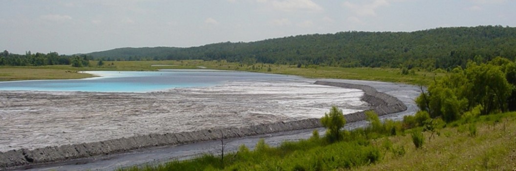
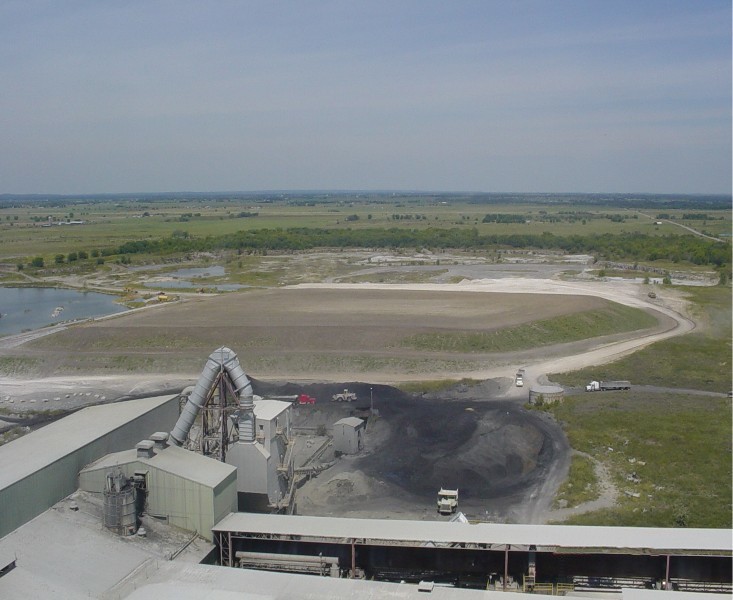
Reclaiming mine sites with Coal Combustion By-Product (CCB), including ash and Cement Kiln Dust (CKD), is the primary focus of the CCB Program. Sites in this program are issued mining permits by the Minerals Program for CKD and Technical Services Program for CCB and the reclamation of such sites involves the placement of CCBs in designated portions of the site. Prior to the permit being issued all mining and reclamation applications are technically reviewed for environmental design and to ensure that the operation being proposed complies with all applicable rules and regulations protecting public health and the environment. Background information including, but not limited to, hydrologic, geologic, land use and soil data is analyzed in order to make certain that environmental balance protection is achieved. Water monitoring points are established prior to CCB placement both on and off the site at locations that will provide representative data on the environmental effects of the site. Such background information is a useful tool in environmental compliance monitoring throughout the life of the permit. Prior to a permit being issued, the operator must obtain all the required permits from other agencies with applicable jurisdiction. This may include, for example, a storm water discharge and an air quality permit.
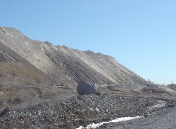
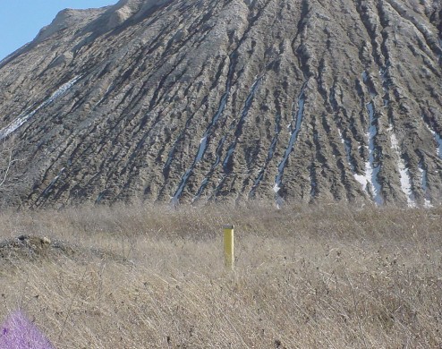
In 2024 there were four (4) sites totaling 293 acres of land (183 acres for fly ash and 110 acres for CKD) across Oklahoma that are permitted to receive CCBs.
The CCB Program involves both Fly Ash and CKD.
These sites are in various stages of reclamation, with some simultaneously conducting different stages of reclamation.
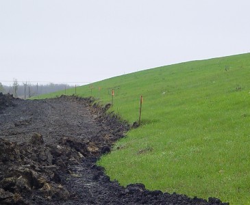
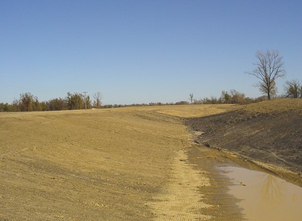
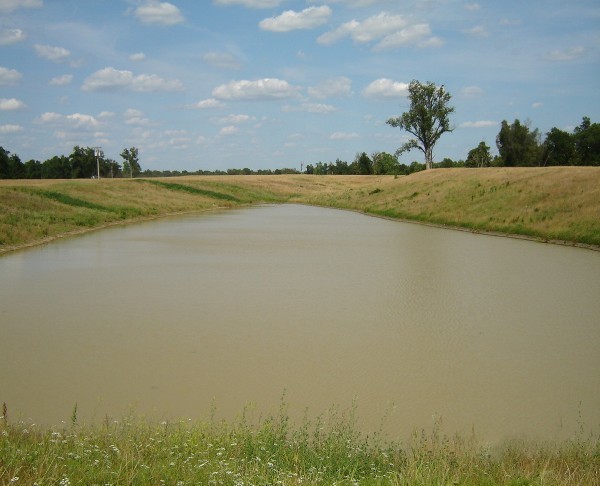
CCB sites are in the reclamation state when issued. When a sufficient amount of CCB has been placed on site, a predetermined amount of cover material and topsoil is laid down. Once sufficient vegetation is established, the site is released.
As reclamation progresses and the need arises, permits may be revised to more accurately reflect the changes that have occurred at the site over time and/or to better monitor the environment being effected by the operations.
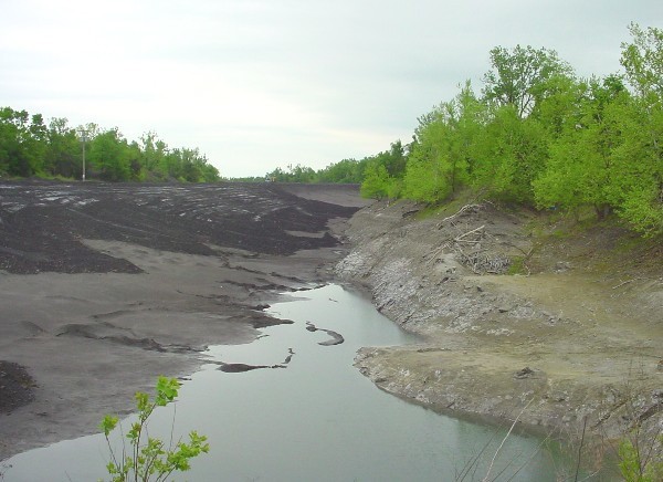
During reclamation, the enforcement of State laws, rules, regulations, and permit conditions related to coal mining and reclamation is administered under the CCB program to ensure continued compliance. Surface and ground water monitoring points are sampled on a scheduled frequency and environmental aspects of the site are closely watched throughout the life of the permit.
Water Monitoring Points
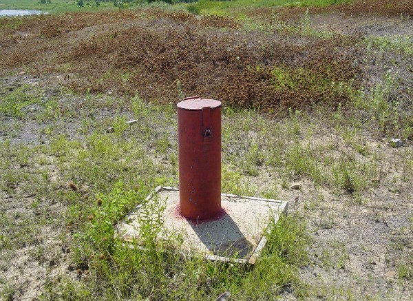
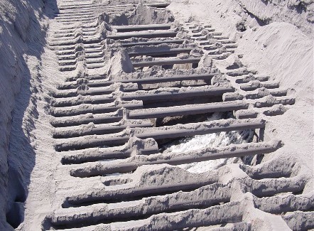
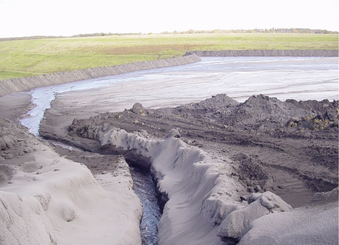
Operators must monitor both surface and ground water on either a semi-annual or an annual basis. Analyses on these monitoring points look at the concentration of a variety of parameters that reflect the water quality of the surrounding area. As evidenced by these analyses to date, water quality levels are unaffected by the placement of CCB at these sites.
It is estimated that more than 500,000 cubic yards of fly ash and 300,000 cubic yards of CKD are placed on sites each year. This number is expected to increase as the CCB Program continues to develop and the benefits of utilizing CCB for reclamation purposes are further realized.
Title 460:30. Coal Combustion By-Productions Standards have been developed to address reclamation standards when CCB is utilized in order to further the mission of this program and to assist the mining industry in meeting its environmental responsibilities in an efficient and effective manner. These standards are a part of the rules regulated by ODM on all of its mine sites throughout Oklahoma.
Both environmental and health and safety inspections are being conducted on all CCB permits to ensure that environmental standards and guidelines are being met and that safe practices are being followed.
One inspector conducts both inspection so to minimize departmental costs and to give the operator/owner one primary contact person at ODM. The same inspector conducts complaint investigations relating to these assigned permitted sites.
When necessary, the CCB Inspector issues Notices of Violations to operators who are out of compliance with State Statutes and Departmental Rules governing environmental and health and safety practices. In 2010 the number of health and safety violations at two (2) sites rose sharply due to increased reclamation activity and additional equipment on site.
Environmental technical assistance also is available for Non-Coal Inspectors, Coal Inspectors and other ODM staff as requested and representation of ODM is provided at interagency meetings and CCB discussion and work groups both statewide and nationally.
In summary, the CCB Program administered through the Technical Services Program of ODM is designed and functions to meet the needs of both the mining industry and the citizens of Oklahoma. Precious land that has endured the hardships of mining is put back into productive service for Oklahoma property owners as crops, grazing land for domestic animals or set aside for wildlife and recreation. With diligent environmental monitoring and careful adherence to the laws of this State, this is becoming an increasing reality.
Abandoned Coal Mines In Tulsa County
Introduction
In February 2008 several articles appeared in the Tulsa new media about underground coal mines and potential problems that can occur from such mines. Part of the reporting included discussion of underground coal mines in and around the Tulsa Fairgrounds area.
The Oklahoma Conservation Commission's (OCC) Abandoned Mine Land (AML) Division, in cooperation with the Oklahoma Geological Survey(OGS) and the Oklahoma Department of Mines (ODM), has develop-ed this fact sheet to provide information on what is known about the past coal mining in Tulsa County, what investigations have been undertaken, and the potential for problems resulting from possible future land subsidence over abandoned coal mines. Land subsidence is a geologic hazard as defined by the United State Geological Survey (USGS).
Background
There are four (4) state and federal agencies with some expertise and jurisdiction over coal mining in Oklahoma. The Oklahoma Department of Mines (ODM) is the state agency responsible for issuing permits and regulating active surface and underground coal mines. The Oklahoma Conservation Commission (OCC)is the state agency responsible for reclaiming abandoned coal mines (both surface and underground) that were mined prior to the enactment of the federal Surface Mining Control and Reclamation Act of 1977. The Oklahoma Geological Survey (OGS) is the state agency responsible for the scientific investigation and reporting of the state's land, water, mineral and energy resources. The Office of Surface Mining (OSM) is the U.S. Department of the Interior is the federal agency responsible for regulating surface coal mining and the surface effects of underground coal mining. OSM works in conjunction with ODM and OCC to regulate active coal mining and reclaim abandoned mine lands.
Coal mining in Tulsa County has been by both underground and surface mining methods. Commercial underground coal mining began in Tulsa County after the turn of the 20th century. The available underground mine maps for Tulsa County on file at ODM range in date from 1910 to 1955. OGS has published research reports and maps of coal mining in Tulsa County. The most important is by Hemish, L.A., published in 1990, entitles Coal Geology of Tulsa, Wagoner, Creek and Washington Counties, Oklahoma: Oklahoma Geological Survey GM-33. Another is by Oakes, M.C., et al., published in 1952, entitled Geology and Mineral Resources of Tulsa County, Oklahoma: Oklahoma Geological Survey, Bulletin 69, 234p. Also, the Tulsa Geological Society has compiled additional information that can be found in Knight, W.V., 1972, Coal and Coal Mining in the Tulsa Area, a document included in A.P. Bennison, W.V. Knight, W.B. Creath, R.H. Dott, and C.L. Hayes, eds., Tulsa Physical Environment - a symposium: Tulsa Geological Society Digest, v. 37, p. 243-251.
Typically the coal beds that have been mined in Tulsa County are 28 to 34 inches thick, dip 0 to 3 degrees west-northwestward and are 0 to 90 feet below the surface. The majority of the areas where coal has been mined by underground methods are 20 feet or greater in depth, but there are areas mined by underground methods where the coal bed is less than 20 feet in depth. Geologic study and drilling will show actual depths of abandoned mines at specific locations.
OCC is in consultation with OGS to review existing blueprint maps and previous studies of coal mining in Tulsa County in an effort to better determine the areas that have been mined by underground methods. While maps exist for many of the underground mines in Tulsa County, it is not a complete set. Examination of these maps indicates that there are other areas known to have been mined but for which maps are not available. The available mine maps may lack data such as depth (from surface to mine rooms) and room height (from floor to mine roof). There is also the challenge of correlating the old maps to features on the surface. OCC is in the process of electronically scanning the old mine maps that are available and then overlaying the maps on aerial photographs of the surface. This has been accomplished for an area around the Tulsa Fairground but remains incomplete for most of Tulsa County. The project is being undertaken to provide a resource to OCC mine reclamation staff who are charged with investigating subsidence incidents due to underground mines in Tulsa County and in other areas of the state.
The AML Emergency Program
- OCC operates the AML Emergency Program under the auspices of the federal OSM. Before OCC can implement the Emergency Program to address an event, OSM must issue a statement declaring a coal-related abandoned mine land emergency to exist. In areas known to have underground mining, OCC investigates all reports that could possibly be related to the underground mining.
Investigations to date in Tulsa County
(a) OCC's records show the location of an open subsidence in a city street and residential yard east of the Sears store at E. 17th St. and S. Erie Ave. on May 16, 1997. OCC consulted with the City of Tulsa whose street maintenance workers fixed the problem as a street repair project.
(b) On Oct. 30, 2000, OCC received a contact from a landowner located at 1202 S. Darlington regarding the possibility of subsidences at 1208 and 1214 S. Darlington. No open hole was observed and no additional report have been received to date.
(c) In March 2003 OCC received a contact from Mr. Joe Etheridge regarding a subsidence adjacent to his driveway at 2324 S. Toledo Ave. Investigation revealed a 4 feet deep, 8 feet long and 5 feet wide concrete box. Upon examination it was determined to be the remains of a water cistern or cellar and was not related to coal mining.
- If a home is damaged by subsidence due to underground mining, OCC can do work to stabilize the home's foundations or, in some situations, move the home. However, the program does not provide funds to repair damage to the house caused by the subsidence. Some states offer mine subsidence insurance to property owners in areas that are undermined, but the State of Oklahoma has no mine subsidence insurance program. Oklahoma Sen. Richard Lerblance (D-Hartshorne) introduced mine subsidence insurance legislation in the 2007 Legislative Session but the bill did not pass.
- OCC is not allowed to use federal AML Emergency Program funds from OSM to perform exploratory drilling in the area to assess the potential of subsidence until a subsidence even occurs
- During the time period since OCC first assumed responsibility for the AML Emergency Program in 1998 to the current date of April 23, 2008, OCC's Abandoned Mine Land Program has reclaimed 43 AML emergency projects at a cost of $801,403.26. None of the emergency AML projects were in Tulsa County.
Conclusions
OCC has electronically scanned more than 60 coal mine maps from the Oklahoma Department of Mines. Dates of these maps range from 1910 to 1955. Based on information from available mine maps and geological reports from the Oklahoma Geological Society (OGS), the OCC and OGS find that the Dawson coal in Tulsa County is 28-34 inches thick and dips less than 5 degrees west-northwestward. Data from OGS map GM-33, Plate 1, shows the mined part of the Dawson coal bed to be mostly 20-90 feet below the surface; however, there are many areas where the coal is less than 20 feet below ground.
OCC, ODM and OGS have no knowledge of health concerns or issues related to water in the underground coal mines in the Tulsa Fairground area.
Only one confirmed min-related incident in Tulsa County has been reported to OCC since the inception of the Oklahoma AML Program in 1982. However, OCC, ODM and OGS believe there is some potential geologic hazard for subsidence about abandoned underground coal mines in Tulsa County. The degree of potential geologic hazards depends on depth to the mine and occurrence of a rigid sandstone bed (layer) in the rock interval between the top of the mine and the surface. Shallow depth and absence of a rigid sandstone layer suggest a higher geologic hazard for subsidence. On the other hand, greater depth and presence of a rigid sandstone layer suggest a lower geologic hazard for subsidence. In order to assess the degree of potential geologic hazard one must drill exploratory holes to measure the depth to the mine and to determine the presence or absence of a rigid sandstone layer.
Oklahoma Conservation Commission
2800 N. Lincoln Blvd., Suite 160
Oklahoma City, OK 73105-4201
Tel: (405) 521-2384
Fax: (405) 521-6686
www.conservation.ok.gov
Oklahoma Geological Survey
100 E. Boyd, Rm. N-131
Norman, OK 73019-0628
Tel: (405) 325-3031
www.ogs.ou.edu
Oklahoma Department of Mines
2915 N. Classen Blvd., Suite 213
Oklahoma City, OK 73106
Tel: (405) 427-3859
www.mines.ok.gov
Office of Surface Mining, Reclamation and Enforcement, U.S. Dept. of the Interior
OSMRE - Mid-Continent Region Field Office
William L. Beatty Federal Building
501 Belle Street, Suite #216
Alton, IL 62002
www.osmre.gov